Lost In Michigan
  • HOME
  • Books
  • the Images
  • The Artist
  • The Journey
  • Shop
  • Cart

Monthly Archives: June 2016

The Time I Really Was Lost and I Found Stephenson

Posted on June 29, 2016 by Mike Sonnenberg Posted in small towns .

stephenson michigan downtown

I was heading from Escanaba to Houghton with my wife on U.S. 2 thru da U.P. and I really was not paying that much attention to the signs on the road and at some point the road split and 2 went north and 41 went south but I did not realize there was an interchange there, it was just a fork in the road and I went the way that looked right to me. so we were driving along and after a while I started noticing signs that said Green Bay and I started seeing a lot of Green Bay Packers flags in the yards and then I started thinking we were going the wrong way, I switched the display on the dashboard over to compass and it said we were heading south and then it really it me, We were going the wrong way. We got to the town of Stephenson and I looked at the map and realized I went about 70 miles the wrong way.  I fugred I was in Stephenson I might as well take a drive thru town. It was a Sunday night and like most northern Michigan small towns everything was closed on Sunday and it was strangely quiet

stephensonmichigan train depot

In the middle of town next to the railroad tracks was this cute little building. I am not sure if it was a depot or something else for the railroad but I am sure it’s been a while since any passengers came in to town by train.

It would mean a lot to me if you Subscribe to Lost In Michigan because Facebook may not show you everything I post. 

enter your email address, I promise I won't send you any spam, its just an automated email that lets you know there is a new post to read

[fbcomments]

The Story of the Saginaw River Rear Range Lighthouse

Posted on June 28, 2016 by Mike Sonnenberg Posted in Lighthouses .

Saginaw Rear Range Lighthouse

In 1867, the U.S. Army Corp of Engineers dredged the Saginaw River channel so that larger vessels could navigate the river. In 1876. a pair of lighthouses were erected in a range light configuration. It is generally believed (but not well documented) that the Saginaw River lighthouse was the first place where range lights were installed.

The “front” range light was constructed on a square timber crib beside the western river bank, and took the form of a 34-foot tall painted-white pyramid framework of timber similar in design to that being used for pierhead beacons throughout the district at the time. With its upper half sheathed, a small enclosed room was created beneath the gallery for the storage of oil and supplies, in which the keeper could seek shelter while tending the light during inclement weather conditions.

The “rear” range light was constructed 2,300 feet south of the mouth of the river. Because of swampy ground, timber piles had to be driven deep into the ground to provide a solid foundation on which timber forms for the concrete base could be erected and filled. Atop this concrete foundation, a square two-story Cream City brick Lighthouse keeper’s dwelling 26 feet 6 inches in plan was constructed. Integrated into the northwest corner of the dwelling, a tapered 53 feet tall square tower with double walls housed a set of prefabricated cast iron spiral stairs. Winding from the cellar to the lantern, these stairs also serve as the only means of access to the first and second floors by way of landings on each floor. Each was outfitted with tightly fitting arch-topped iron doors designed to stem the spread of fire between floors. The living quarters consisted of a kitchen, parlor and oil storage room on the first floor, and three bedrooms above. The tower was capped with a square iron gallery, supported by five cast iron corbels on each of its four sides. An octagonal cast iron lantern was installed at its center, with a fixed white fourth-order Fresnel lens placed at a focal plane of 61 feet.

The range lights were converted to electricity in 1915. The light in the rear tower was deactivated in 1960 when a new channel was dredged requiring a new set of range lights to mark it. The Structure was used as the residence for men assigned to the associated US Coast Guard facility until the 1970s. At that time, the Coast Guard Station was moved across the river to a new building in order to have more space. The lighthouse remained empty until 1986. Dow Chemical Company, which owned the surrounding land, purchased the facility and boarded it up. In 1999, the Saginaw River Marine Historical Society approached Dow to collaborate to restore the lighthouse and open it to tourists.

During the tall ship celebration in Bay City it was opened to tourists and I was fortunate to get a tour of it and some photos. It will be opened once again this year to visit during the tall ship celebration, you can find out more at the Saginaw River Marine Historical Society facebook’s page HERE

you can get a print of this pic or any of my images HERE

It would mean a lot to me if you Subscribe to Lost In Michigan

enter your email address, I promise I won't send you any spam, its just an automated email that lets you know there is a new post to read

[fbcomments]

The Old Car Along The Road

Posted on June 26, 2016 by Mike Sonnenberg Posted in Forgotten Places .

abandoned Michigan

I saw this old abandoned car along side the road near Weidman. I am sure it longs for the day the family would pile in with a picnic basked and go for a road trip. I am not sure what kind if cat it us but like most cars of its era I can only think that most of its parts, and maybe the car itself was built in Michigan.

you can get a print of this pic or any of my images HERE

It would mean a lot to me if you Subscribe to Lost In Michigan

enter your email address, I promise I won't send you any spam, its just an automated email that lets you know there is a new post to read

[fbcomments]

Another Abandoned Michigan Mystery House

Posted on June 23, 2016 by Mike Sonnenberg Posted in Forgotten Places .

abandoned house in Michigan

I say this is a Mystery House because I am not sure where It’s located, I know i was somewhere between Owosso and Flint, but I cant for the life of me remember where I was at when I took this pic a few years ago. To some people that may sound strange, but I take a lot of pics, I mean A LOT OF PICS like 50,000 a year, I really don’t pay attention to what road I am on or small town I am near, many times I am just driving back roads aimlessly turning right or left or whatever way I feel like going.

I do get asked about the locations of some places, and requested that I post the exact longitude and latitude of the pics, which I know is possible, but I don’t like posting exact locations. I have done that, only to find out later, selfish and evil people have trespassed and vandalized or stolen stuff from the property. That’s why I only give out an approximate location. I am also asked a lot when I give a name of a small town where it is located, I figure it’s easy to look up on google maps where they are located.

If I am little vague on locations then you will have to do a little research to discover for yourself where something is located, and you might also find something new, that is how I find some of the places I find. I start researching something then go off on a tangent, and find something else. My Theory is, I could tell you exactly where it is, but if I give you a rough Idea and then you can search for it yourself. and who knows what you will find while looking. and sometimes, like in this case, I don’t even know myself where the house in this pics is located. I hope I encourage you to get out and explore Michigan.

It would mean a lot to me if you Subscribe to Lost In Michigan

enter your email address, I promise I won't send you any spam, its just an automated email that lets you know there is a new post to read

[fbcomments]

The Point Betsie Lighthouse: Standing Guard Over Lake Michigan Since 1858

Posted on June 21, 2016 by Mike Sonnenberg Posted in Lighthouses .

point betsie light house michiga

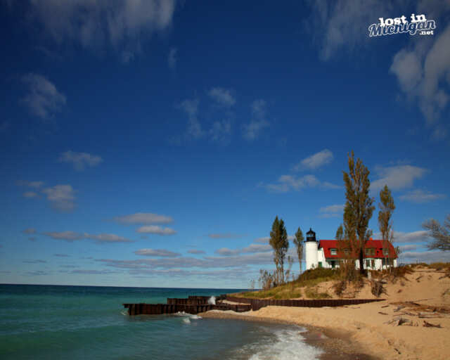
Completed in 1858 the Point Betsie Lighthouse, north of Frankfort, is the oldest building in Benzie County. Standing along the shores of Lake Michigan marking the southern entrance to the Manitou Passage. In 1875 one of the first life saving stations was established by the U. S. Life Saving Service at the lighthouse. This was the last manned lighthouse on Lake Michigan, and the last Michigan lighthouse to lose its keeper after it was automated in 1982.

point betsie light house Michigan
Erosion of the sandy point has always been a problem threatening the lighthouse, and in 1890 a ring of concrete was inserted under the tower. A curved breakwall was constructed at the water’s edge to absorb the energy of the waves crashing into the shore. I am thinking the blocks protruding from the surface of the concrete are there to keep the ice from Lake Michigan from pushing up to the lighthouse, but I could not find anything to confirm this.

Point Betsie Lighthouse is said to be one of Americas most photographed lighthouses, and with its red gamble roof and its green trim it is a beautiful lighthouse standing watch guiding ships as they pass by. if you want to visit the lighthouse you can find out more at their page HERE http://www.pointbetsie.org/

you can get a print of this pic or any of my images HERE

It would mean a lot to me if you Subscribe to Lost In Michigan

enter your email address, I promise I won't send you any spam, its just an automated email that lets you know there is a new post to read

[fbcomments]


An Old Barn Near Lupton

Posted on June 19, 2016 by Mike Sonnenberg Posted in Barns and Farms .

michigan barn

Another old barn I found on my travels thru the state, and this one was near Lupton. Like most of the other barns I have photographed, I know nothing about it’s history, other than at one time it was the pride of the family that built it to shelter their horses, or tractors, or whatever you put in a barn. I have been a city kid all my life, and I am not an expert on farming, other than without them I would not have much to eat.

you can get a print of this pic or any of my images HERE

It would mean a lot to me if you Subscribe to Lost In Michigan

enter your email address, I promise I won't send you any spam, its just an automated email that lets you know there is a new post to read

[fbcomments]

Bond Falls Scenic Site is a Site to See

Posted on June 16, 2016 by Mike Sonnenberg Posted in Waterfalls .

bond falls michigan waterfall

Bond Falls near Paulding in the west side of the Upper Peninsula is a truly magnificent waterfall to see. It’s a Scenic Site maintained by the DNR, and if you have a recreation passport on your vehicle registration, then you can visit without having to stop and pay for a pass like all the people I saw from Wisconsin doing.  It’s a long trip from ” The bridge” across the U.P. to see them, but it’s worth the trip, and there are several trails and boardwalks to allow for different viewing locations with multiple waterfalls along the Ontonagon River to view and photograph.

you can get a print of this pic or any of my images HERE

It would mean a lot to me if you Subscribe to Lost In Michigan

enter your email address, I promise I won't send you any spam, its just an automated email that lets you know there is a new post to read

[fbcomments]

Michigan’s Most Famous American Flag

Posted on June 14, 2016 by Mike Sonnenberg Posted in Forgotten Places, Landscapes .

Brick Flag Bay City Michigan

The people on the west side of the state probably won’t recognize this flag, but the people on the east side of the state that travel I75 will recognize this brick flag that stands along the highway near Bay City. It has the 50 state design on one side and the bicentennial design with the circle of stars on the other. For some, it marks the dividing line of ” Up North” on the way north, and for others, it means they are almost home when heading south. The flag was built in 1975 by local Bay City businessman Jim Graham as a way to promote an amusement park he wanted to build called ” Little Michigan. The park was supposed to be in the shape of Michigan with ponds in the shape of the 5 great lakes. The park never did get built, but the flag still stands waving at motorists as they drive by.

Lost In Michigan books are ON SALE this weekend at Amazon to learn more click HERE


It would mean a lot to me if you Subscribe to Lost In Michigan

enter your email address, I promise I won't send you any spam, its just an automated email that lets you know there is a new post to read


Leave a comment .

The Dreadful Reality of the Downtrodden at Eloise Asylum

Posted on June 13, 2016 by Mike Sonnenberg Posted in Cemetery, Forgotten Places, Haunted Places, Michigan Historical Markers .
eloise asylum haunted michigan

one of the few remaining buildings from the Eloise complex.

Some say that the Eloise Asylum near Westland on Michigan Ave. is one of Michigan’s most haunted places, I am not sure about that claim, but I would say it’s one of Michigan more interesting places, with a lot of history both good and sad.

The place began in 1839 when a log cabin known as the Black Horse Tavern and its property was converted into a poor house and 35 of the overcrowded tenants at the Wayne County poor house in Hamtramck were transferred to the newly constructed buildings. For years it was known as the Wayne County Poor House until a post office was opened in 1894 and named after Eloise Dickerson Davock the daughter of Detroit’s postmaster.

In 1913 there were three divisions: The Eloise Hospital(Mental Hospital), the Eloise Infirmary (Poorhouse) and the Eloise Sanitarium (T.B. Hospital) . Over the years the complex continued to grow with about 10,000 residents at its peak during the Great Depression. It had its own police and fire department, railroad and trolley stations, bakery, amusement hall, laundries, and a powerhouse. It also had many farm buildings including a dairy herd and dairy barns, a piggery, a root cellar, a Tobacco curing building, and employee housing.

Eloise was one of the first if not the first hospital to use x-rays for diagnosis performed by Dr.Albarran. Patients came from Detroit and other communities to have x-rays done.  It also housed the first kidney dialysis unit in the State of Michigan and was a pioneer in the field of Music Therapy.

eloise cemetery bw

the old Eloise Cemetery on Henry Ruff Road.

The other part of Eloise that remains, are the cemeteries and with a complex that had about 10,000 people living there, death was a regular occurrence. There were a few different locations that the bodies of the patents and residents of the poor house were buried. One of the cemeteries is about a mile away down Henry Ruff road and is nothing more than a field with small stone markers engraved with only a number for the body buried below. It seems rather cruel and inhumane that a person is remembered as a number and not even a name was placed on the marker. They used the cemeteries up until 1948 after that a law was enacted to use the bodies as cadavers for medical training. ( was not able to get a pic of the markers since the cemetery is fenced off and says no trespassing, and I really don’t want to go to jail)

eloise kay beard building

The main building left standing from the former Eloise Complex

The farm operations ceased in 1958 and some of the large psychiatric buildings were vacated in 1973. The psychiatric division started closing in 1977 when the State of Michigan took over the psychiatric division. The general hospital closed in 1984. Many of the buildings are gone and some of the property has been redeveloped into a golf course and condominiums. There is a Michigan Historical Marker near the parking lot.

Lost In Michigan books are ON SALE this weekend on Amazon HERE

If you like my posts it would mean a lot to me if you will subscribe for email updates

enter your email address, I promise I won't send you any spam, its just an automated email that lets you know there is a new post to read


The City of Howell and it’s Beautiful Historic Courthouse

Posted on June 12, 2016 by Mike Sonnenberg Posted in courthouses, Michigan Historical Markers, Uncategorized .

Livingston County Courthouse howell

On 24 March 1836, the legislature passed an act organizing Livingston County and Howell was slated to become the County seat. This claim was vigorously opposed by a group from Brighton until the county buildings were actually erected 12 years later.  The town was originally called Livingston Center because it was in the center of the county. The area was platted by Flavius Crane and and Edward Brooks, and they named it for Thomas Howell, a friend of Mr. Brooks, and the son of Judge Howell in Canandaigua N.Y.

Albert E. French designed the courthouse a two-and-a-half story brick and stone building. This edifice, completed in 1890, shows influence of Richardsonian architecture and has maintained many of its original Victorian furnishings. Peter and Maria Cowdry donated the land for the courthouse square with the provision that it revert to their heirs if no longer used for a courthouse. Local citizens presented the clock to the county as a gift. The people of Livingston County voted in 1976 to restore their courthouse which is an area landmark.

It would mean a lot to me if you Subscribe to Lost In Michigan

enter your email address, I promise I won't send you any spam, its just an automated email that lets you know there is a new post to read

[fbcomments]

Next Page »

Subscribe to Blog

Enter your Email to receive new posts notifications

Categories

  • autumn
  • Barns and Farms
  • Bars and Restaurants
  • Benchmarks
  • Bridges
  • calendars
  • castles
  • Cemetery
  • Churches
  • cities
  • courthouses
  • Dam
  • Detroit
  • Fire Houses
  • Forgotten Places
  • General Store
  • Ghost Murals
  • Ghost towns
  • Giveaways
  • Grain Elevators
  • Haunted Places
  • Historic Places
  • Houses
  • Iconic Buildings
  • island
  • Landscapes
  • Library
  • Lighthouses
  • Michigan Historical Markers
  • Michigan State Parks
  • Mills
  • Murders
  • Nature
  • Parks
  • people
  • Photography Tips
  • presentations
  • Restaurants
  • Schools
  • Ships and Boats
  • Sleeping Bear Dunes
  • small towns
  • SP March Madness
  • State Parks
  • Thumb
  • Train Depots
  • Uncategorized
  • upper peninsula
  • Water Tower
  • Waterfalls
  • Winter Wonderland

Archives

Pages

  • Books
  • Cart
  • Checkout
  • My Account
  • Shop
  • Shopping Cart
  • Store
  • the Images
  • The Journey
  • The Artist

Archives

  • March 2021
  • February 2021
  • January 2021
  • December 2020
  • November 2020
  • October 2020
  • September 2020
  • August 2020
  • July 2020
  • June 2020
  • May 2020
  • April 2020
  • March 2020
  • February 2020
  • January 2020
  • December 2019
  • November 2019
  • October 2019
  • September 2019
  • August 2019
  • July 2019
  • June 2019
  • May 2019
  • April 2019
  • March 2019
  • February 2019
  • January 2019
  • December 2018
  • November 2018
  • October 2018
  • September 2018
  • August 2018
  • July 2018
  • June 2018
  • May 2018
  • April 2018
  • March 2018
  • February 2018
  • January 2018
  • December 2017
  • November 2017
  • October 2017
  • September 2017
  • August 2017
  • July 2017
  • June 2017
  • May 2017
  • April 2017
  • March 2017
  • February 2017
  • January 2017
  • December 2016
  • November 2016
  • October 2016
  • September 2016
  • August 2016
  • July 2016
  • June 2016
  • May 2016
  • April 2016
  • March 2016
  • February 2016
  • January 2016
  • December 2015
  • November 2015
  • October 2015
  • September 2015
  • August 2015
  • July 2015
  • June 2015
  • May 2015
  • April 2015
  • March 2015
  • February 2015
  • January 2015
  • November 2014
  • October 2014
  • September 2014
  • August 2014
  • July 2014
  • June 2014
  • May 2014
  • April 2014
  • March 2014
  • February 2014
  • January 2014
  • November 2013
  • October 2013
  • September 2013
  • August 2013
  • July 2013

Categories

  • autumn (55)
  • Barns and Farms (76)
  • Bars and Restaurants (5)
  • Benchmarks (1)
  • Bridges (14)
  • calendars (9)
  • castles (9)
  • Cemetery (42)
  • Churches (91)
  • cities (8)
  • courthouses (20)
  • Dam (15)
  • Detroit (19)
  • Fire Houses (21)
  • Forgotten Places (170)
  • General Store (15)
  • Ghost Murals (3)
  • Ghost towns (49)
  • Giveaways (21)
  • Grain Elevators (22)
  • Haunted Places (62)
  • Historic Places (109)
  • Houses (195)
  • Iconic Buildings (22)
  • island (1)
  • Landscapes (8)
  • Library (22)
  • Lighthouses (91)
  • Michigan Historical Markers (93)
  • Michigan State Parks (18)
  • Mills (3)
  • Murders (15)
  • Nature (18)
  • Parks (7)
  • people (20)
  • Photography Tips (4)
  • presentations (9)
  • Restaurants (13)
  • Schools (71)
  • Ships and Boats (12)
  • Sleeping Bear Dunes (2)
  • small towns (61)
  • SP March Madness (5)
  • State Parks (7)
  • Thumb (46)
  • Train Depots (49)
  • Uncategorized (147)
  • upper peninsula (111)
  • Water Tower (8)
  • Waterfalls (25)
  • Winter Wonderland (22)

WordPress

  • Log in
  • WordPress

CyberChimps WordPress Themes

© Lost In Michigan